What can be observed
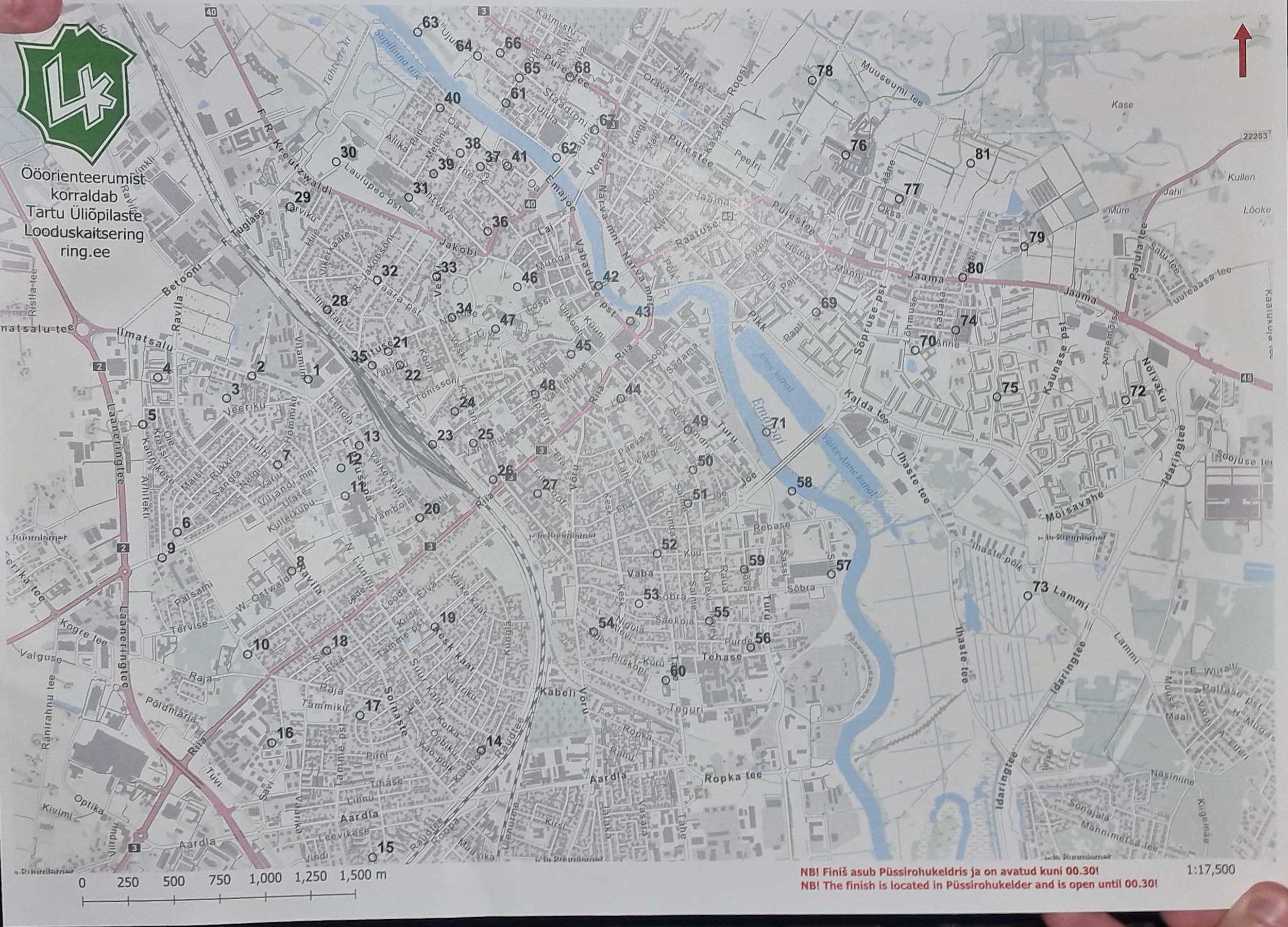
Numbered open circles span the printed Tartu street map. Labels 1–81 are visible after rectification and close inspection.
Interactive evidence explorer
Inspect the original sheet, verify all 81 detected circle centres, review the disputed geographic transform, then compare best-found walking routes under different pace and time limits.
01 · Original evidence
This is the exact image supplied in Discord. The sheet is photographed vertically with perspective, curved paper, fingers at two corners, and a complete printed control map visible across the frame.
1552379705661853728Numbered open circles span the printed Tartu street map. Labels 1–81 are visible after rectification and close inspection.
The paper is rotated, curved and viewed obliquely. Detection coordinates are therefore measured on a perspective-rectified image, not directly on the camera pixels.
The exact source image, asset hashes, all 81 rectified circle centres, and the later retraction are frozen together so the evidence chain remains auditable.
02 · Supported layer
These source-image centres and visible labels remain supported. Select any control to inspect its exact rectified pixel location and cross-highlight it on the provisional map.
03 · Disputed layer
The marker map makes the disputed transformation inspectable rather than hiding it. Select markers and compare them with the source detections above.
04 · Experimental route lab
Change either constraint. The app converts them into a maximum walking distance and selects the lexicographically best precomputed candidate: most controls first, then shortest distance.
Route frontier
Visit order
Preset comparison
Method & provenance
Original photo, rectified image, 81 visible labels and their source-image circle centres.
Image-to-reference transformation, WGS84 coordinates and claims about which real-world road, bank or junction contains each control.
Pedestrian shortest paths and prize-collecting routes derived from the retracted coordinates. Useful for exploring the optimization model only.
Fixed start: University of Tartu Old Observatory. Fixed finish: Püssirohukelder. For each distance budget, optional controls are optimized over an OpenStreetMap pedestrian shortest-path matrix. The objective is lexicographic: maximize visited controls, then minimize route distance. The static frontier combines three RoutingModel strategies at 4–42 km plus the extended 49-control and exact-50 searches. Results are “best found”, not globally proven.
Source photo message: 1552379705661853728. Refreshed 81-control extraction message: 1552404436729471037. Retraction message: 1552459644243550350. The app ships exact frozen source assets and hashes in its data bundle.